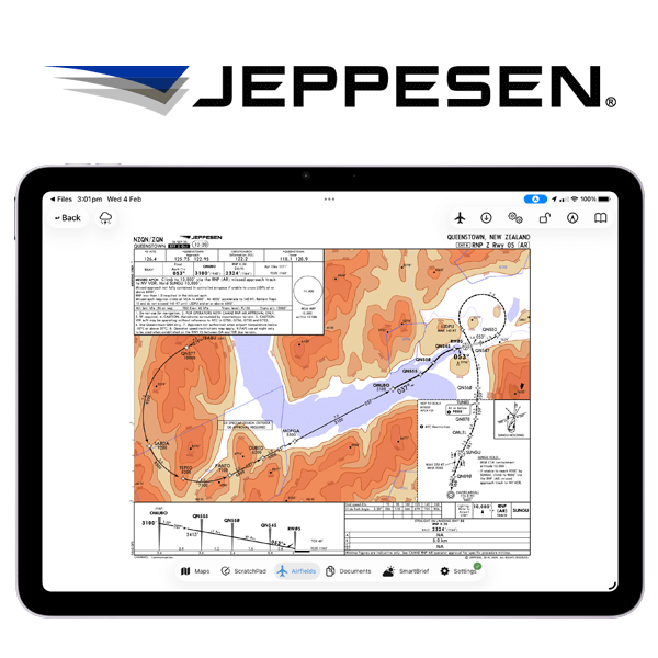
Jeppesen Plates Now Available In OzRunways!
View Jeppesen terminal charts and Jeppesen Airway Manuals in all the familiar ways in OzRunways, whether for flight planning or inflight reference. Available in our new Ultimate tier.

What's New in v14
In 2026 we introduced a refreshed subscription lineup featuring Premium v14 capabilities for all pilots. Choose Essential for all your core smart EFB tools, Plus to access Internet ADS-B Traffic, and Ultimate to view Jeppesen Plates directly within OzRunways.
v14 requires iOS/iPadOS 17 and macOS 14 or above
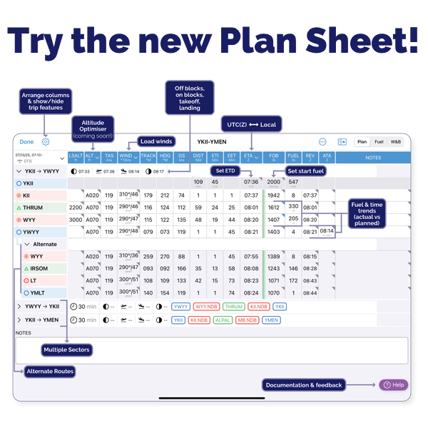
New Plan Sheet
Powerful new features including:
Multi Sector planning
Fuel and time trends
En route alternates and alternate routes
Customisable layout
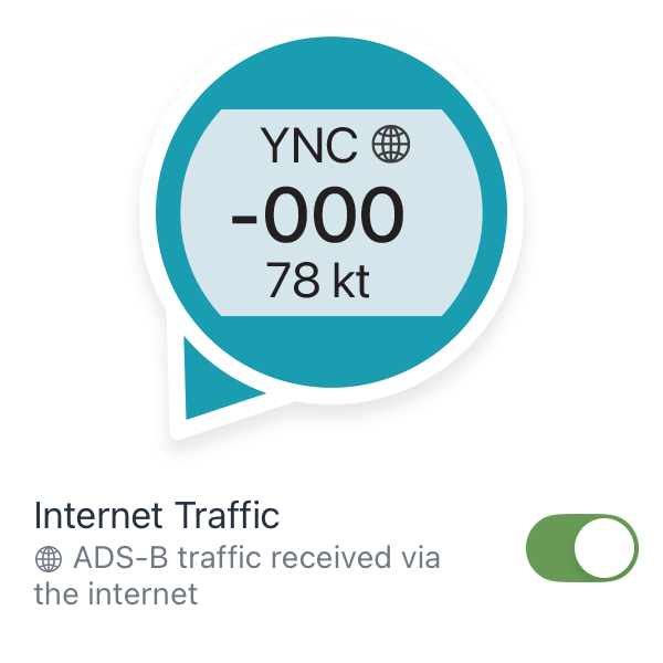
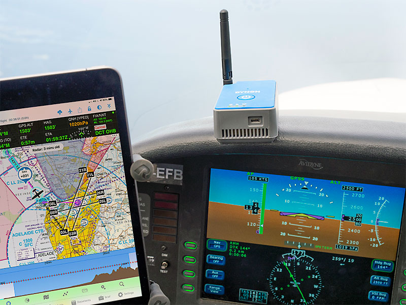
Internet Traffic
Stream live global aircraft positions directly to your EFB from home, in the hangar, or en-route. Uses a cellular or Wi-Fi connection. Further enhances the existing OzRunways Traffic system. *Requires Plus subscription.
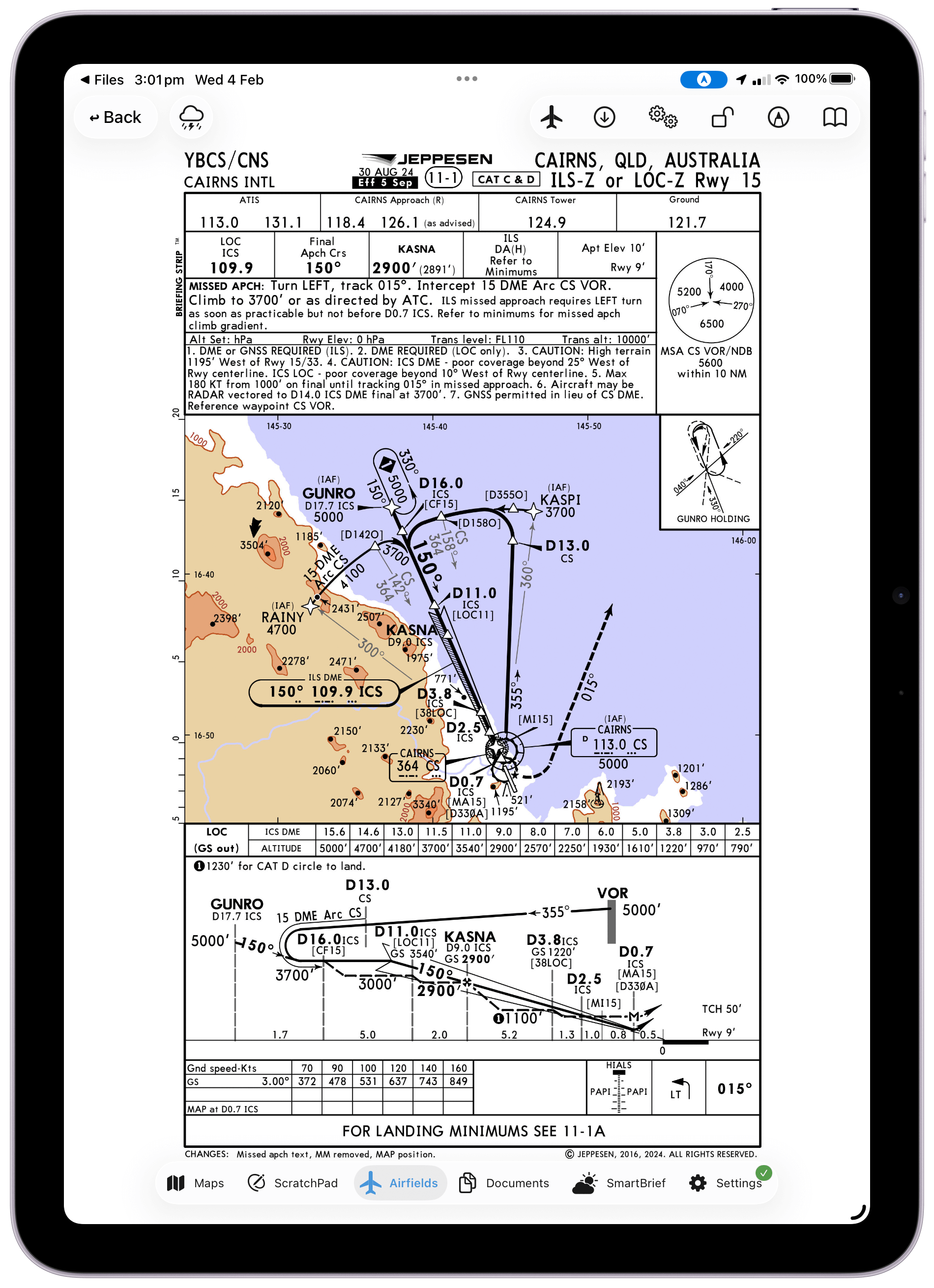
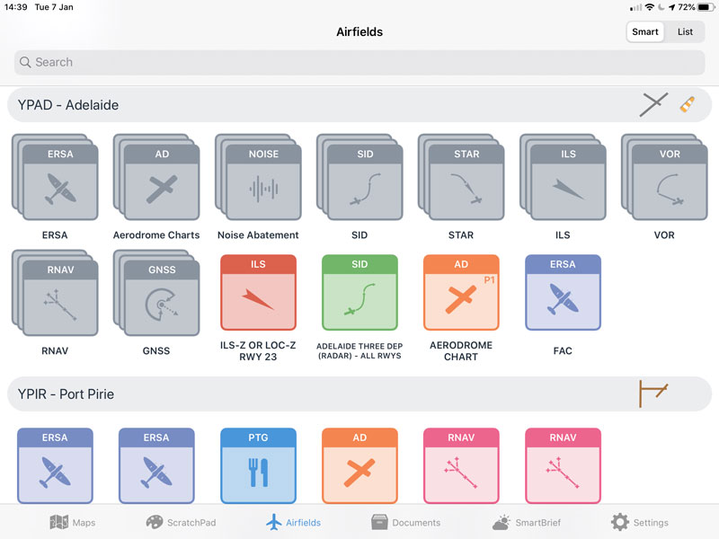
Jeppesen Plates
View Australian or New Zealand Jeppesen terminal charts and Jeppesen Airway Manuals in all the familiar ways in OzRunways, whether for flight planning or inflight reference. *Requires Ultimate Subscription.
As well as dozens of other minor changes, improvements and bug fixes.
Highlights From v13
Our team of experienced pilots have developed features as a result of listening to the frustrations of our aviation community. It's no wonder Australian and New Zealand pilots from recreational, airlines, and military rely on OzRunways v13 to make flying easier, safer and quicker.
v13 requires iOS/iPadOS 16 and macOS 13 or above
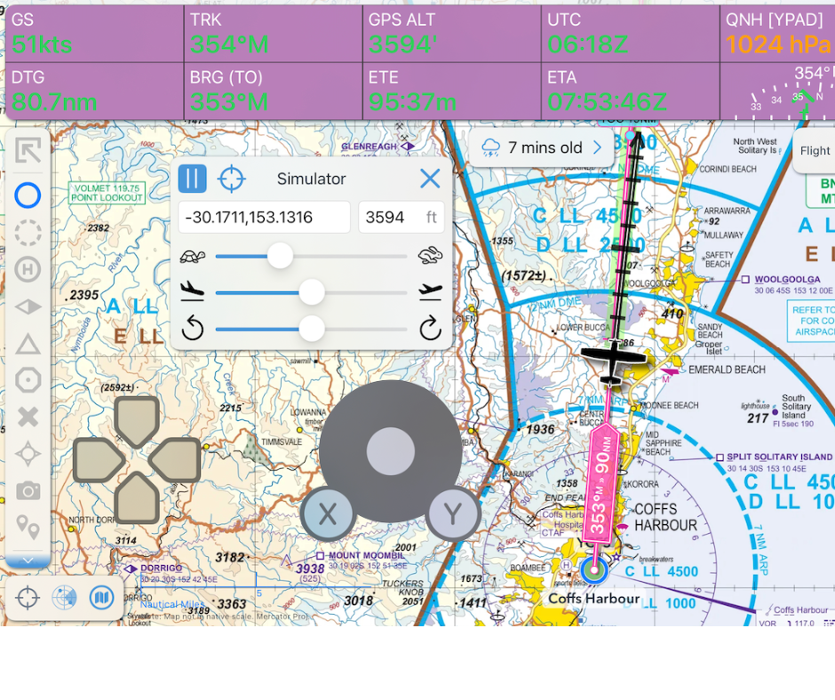
In-App Simulator Controls
Use OzRunways on the ground and in your own time without needing an external simulator. In Settings toggle ON 'Simulator Mode' and 'Enable in-app simulator controls'. Great for pre-flight practice and a much cheaper alternative to learning while airborne!
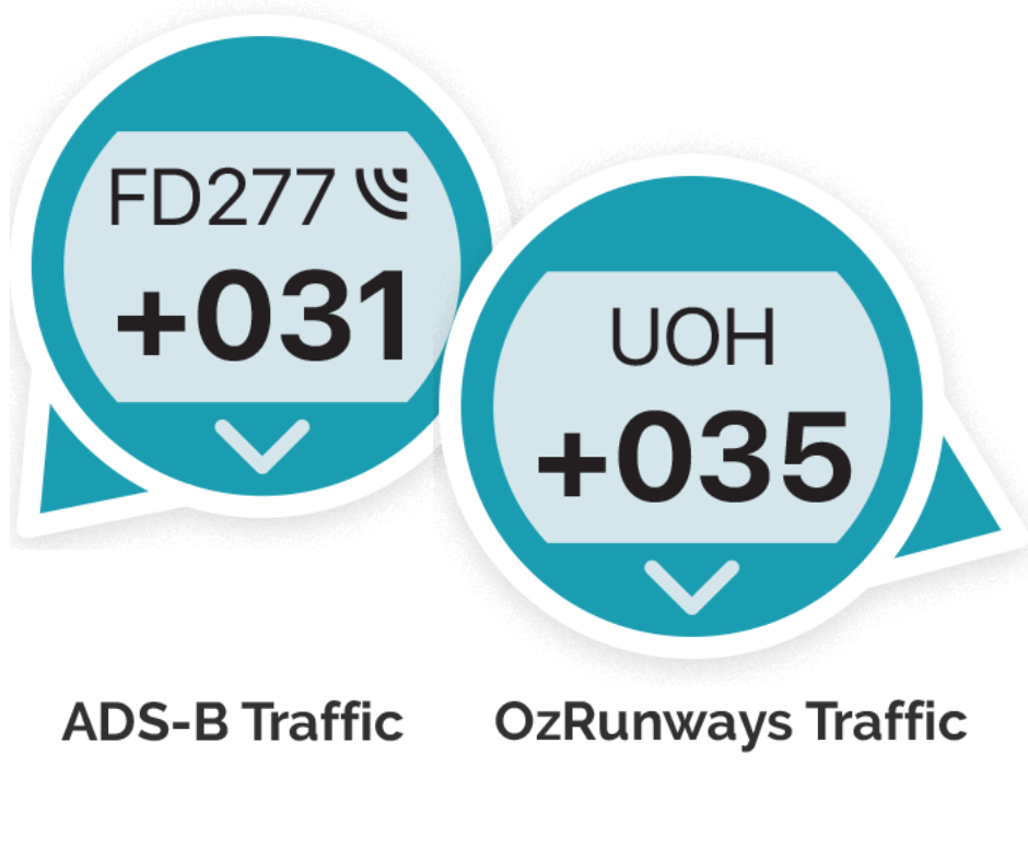
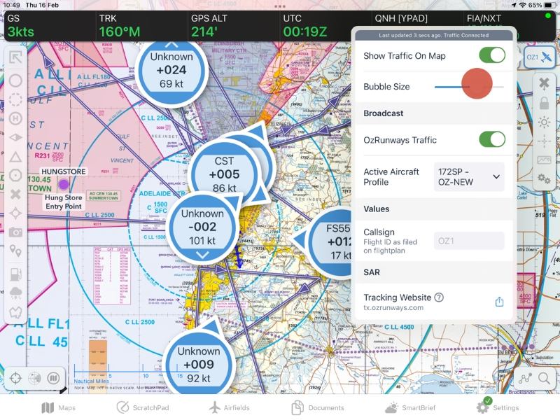
Improved Traffic Bubbles
View the enhanced teal colour of all traffic bubbles for better visibility. ADS-B traffic (previously dark blue) is now indicated by a 'radio wave' symbol next to the callsign to differentiate from OzRunways Traffic (previously light blue).

Changes to Supported Devices
Some devices are version limited and are not compatible with OzRunways v13. The following will no longer receive new features or app updates: iPad mini 4, iPhone 7, iPhone SE (Gen 1), and iPhone 6S / 6S Plus.
As well as dozens of other minor changes, improvements and bug fixes.
Highlights From in v12
We've solved the problem of nonsense NOTAMs hiding the ones that matter and impeding flight safety! In v12, we extract geolocation data for every NOTAM in Australia & New Zealand. Now you can visualise, filter, and easily read only the NOTAMs and airspace that actually affect you.
v12 requires iOS/iPadOS 15 or above
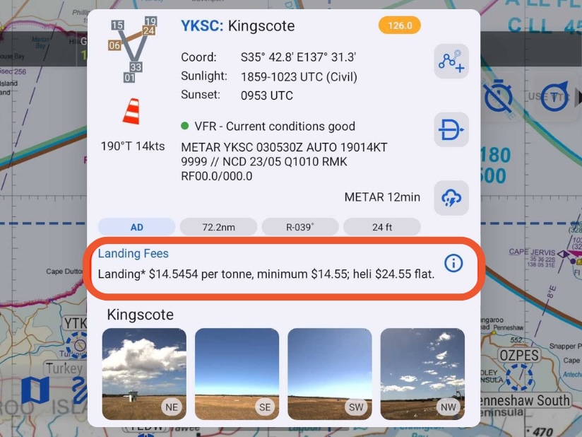
Landing Fees
Where available, Landing Fees are now shown in Airport Details on the Closest Points popup. Just another great tool to help your planning, and less surprises after touchdown.
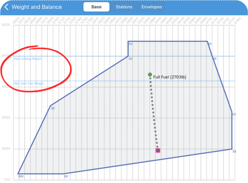
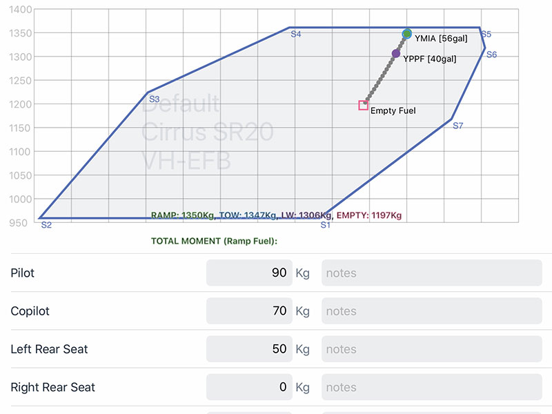
Enhanced W&B Envelope
Visually locate markings for Aircraft Profile weight limitations. Includes MTOW, Max Ramp Weight, Max Zero Fuel Weight, and Max Landing weight.
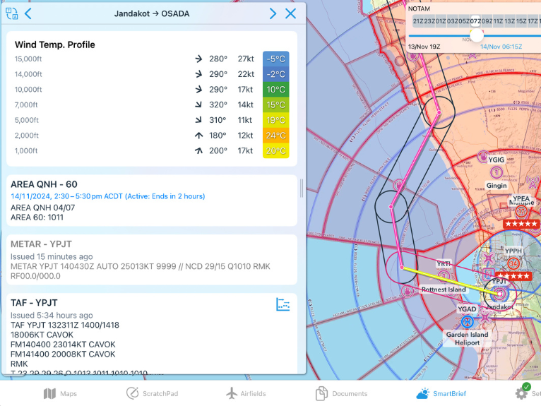
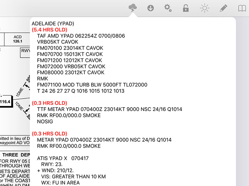
SmartBrief Sector Briefing
NOTAMs, Significant Weather, and all aerodrome weather on route, is now available for each flight plan sector. Activate by creating a multi-sector flight plan, then tap the magenta line in SmartBrief to view the sector briefing.
Multi-Window Split Screen
Simultaneously run two OzRunways views. Enable the Plan Sheet Auto-Split so it always opens in a split window when tapped from the map screen. Or, try the Plan Sheet Slide Over, allowing you to open an additional Plan Sheet window from the Map Screen for side-by-side views.
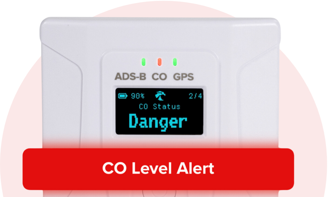
ForeFlight Sentry Support
We now integrate with Sentry by ForeFlight! Benefit from industry-leading safety and accuracy features unique to Sentry devices, such as Carbon Monoxide (CO) in-app alerts, AHRS support and calibration, and to-the-meter WAAS GPS position data.
Weather Overlay Time Selector
There's now a convenient way to better understand evolving conditions. Tap the '>' arrow on the 'x mins old' timestamp to play, pause or select a frame from the Weather Overlay.
Glide Assistant
View your glide distance to ground level using a real-time glide plot for improved navigation awareness in an emergency. Calculated using the Aircraft Glide Profile (eg 9:1) and forecast GPWT winds.
See What's Enroute
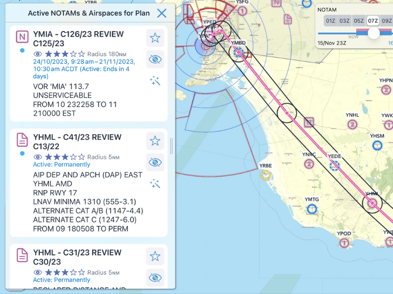
NOTAMs for plan now only show those that actually intersect your track (+/- 5NM), rather than the entire briefing area, reducing the number to read by around 80%.
Category Filtering
Using the buttons on the right of SmartBrief, you can filter out the NOTAM categories that do not affect you, or hide individual NOTAMs completely.
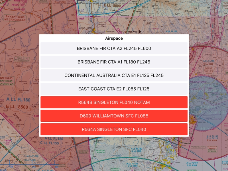
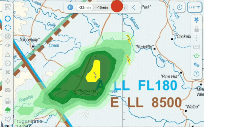
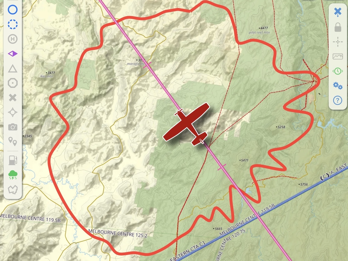
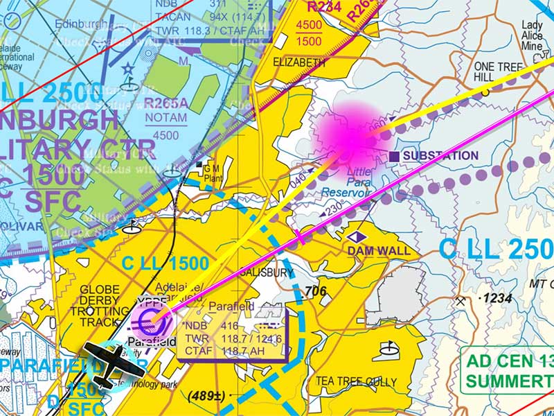
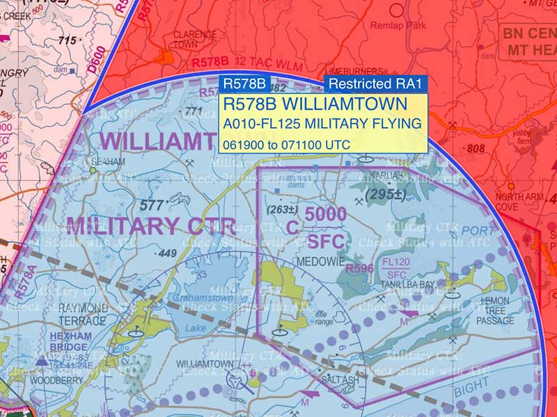
Trust Restricted Airspaces
All restricted airspaces, including NOTAMs, are now intelligently merged onto SmartBrief and the main map. See exactly what you can fly through with confidence in the size, status, and timing. Saved and available offline.
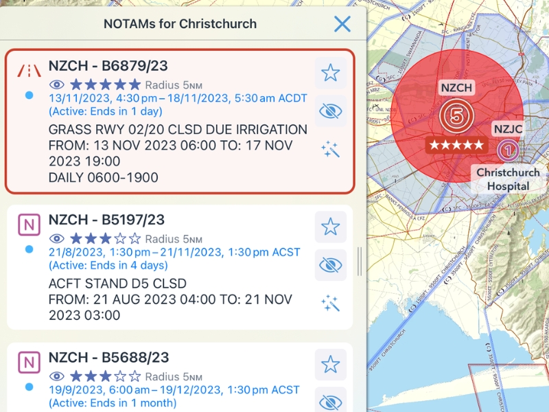
Importance Filtering
NOTAMs are ranked based on their type and importance. For example: runway or airport closures are automatically assigned as ★★★★★ and are highlighted on the map.
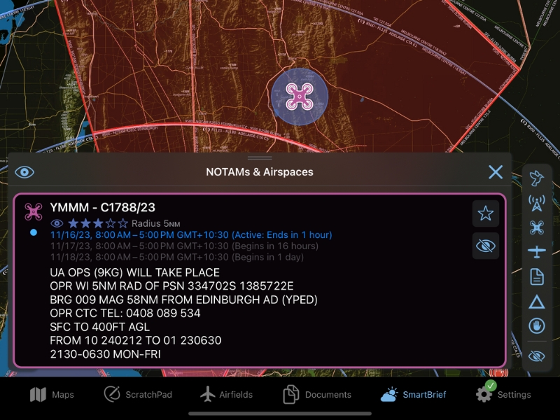
Dynamic Activation Times
Airspace activation times are now more detailed, including amendments by NOTAM. Use the SmartBrief time slider to see whether your flight is impacted. Human-readable activation times make them easier to read.
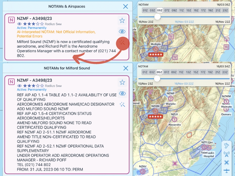
Plain-English Translation
Using AI text decoding, NOTAMs with unfamiliar acronyms can be translated into human-readable summaries.
Dark Mode Colour Invert
Standard Dark Mode colours have been further improved. Check it out on all approach plates, documents and maps (ERCs/TACs/Open Street Map/PCA only).
Live Text Recogntion
This feature enables easy text selection so you can quickly copy/paste etc.Available on all airfield documents (ERSA/DAPs etc.).
As well as dozens of other minor changes, improvements and bug fixes.
Highlights From v11
We've used this opportunity to vastly improve the layout and navigation of the settings menu plus the placement of primary icons. In v11, we've created our easiest and most intuitive app design yet. Plus, launched our most exciting EFB feature ever - SmartPlates!
v11 requires iOS/iPadOS 14 or above
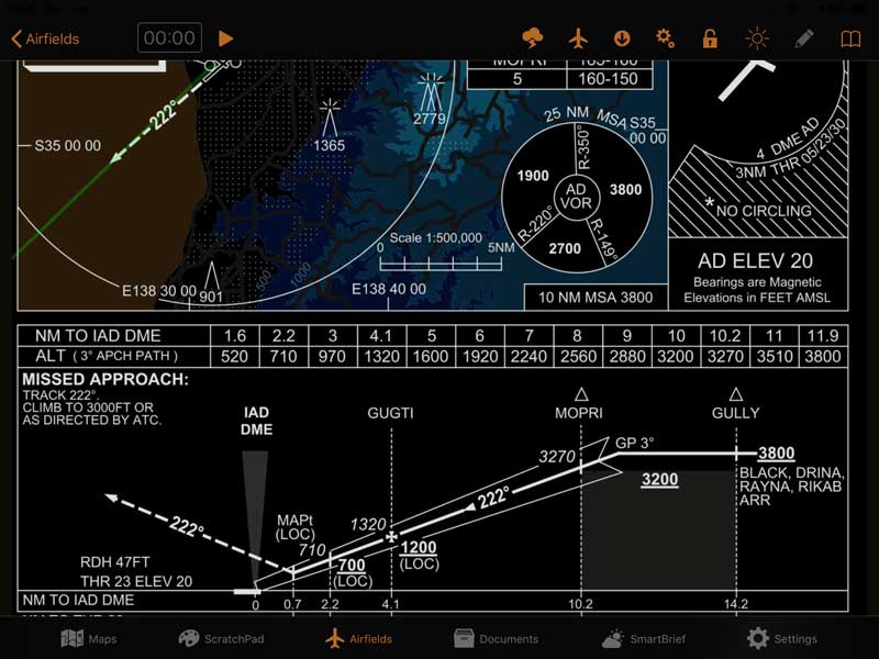
IFR SmartPlates
After 18 months in development, SmartPlates will significantly reduce workload and errors during your most critical phases of flight. It's the first feature of our upcoming IFR Ultimate subscription and is currently free for Australian IFR Premium subscribers to preview!
Leverage increased situational awareness by visualising your approach with dynamic coloured overlays such as Descent Highlighting, MSA Identifier, and Sector Entry Assistant.
Toggle ON for supported RNP and ILS Approaches via the Settings icon on DAPS plates. Supported plates are annotated with SMART in the bookmarks list.
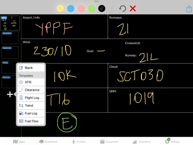
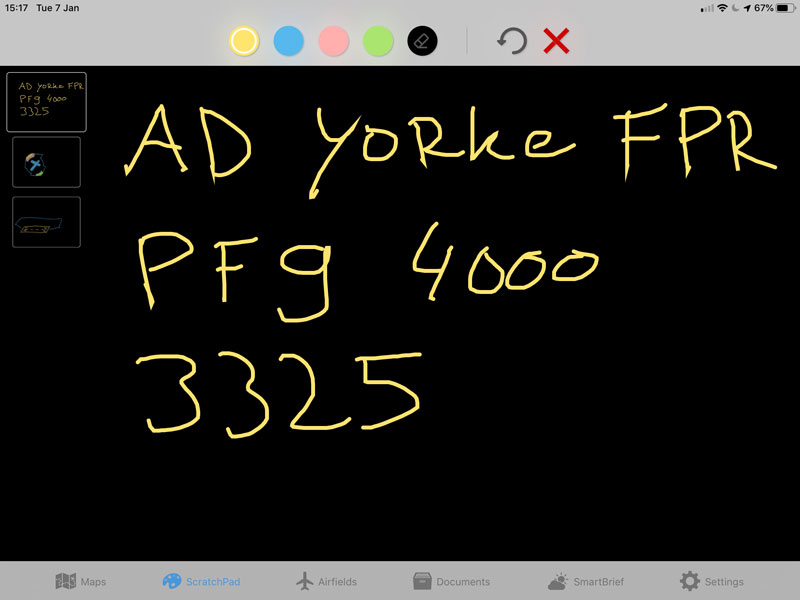
ScratchPad Templates
Be guided by our collection of pre-filled headings when recording information during planning and throughout every flight. A left-swipe to delete ScratchPad pages feature has been included, plus, you can share between devices or save as a pdf for self or company records.
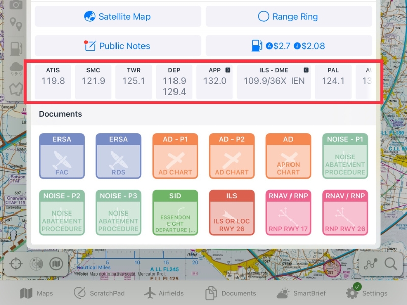
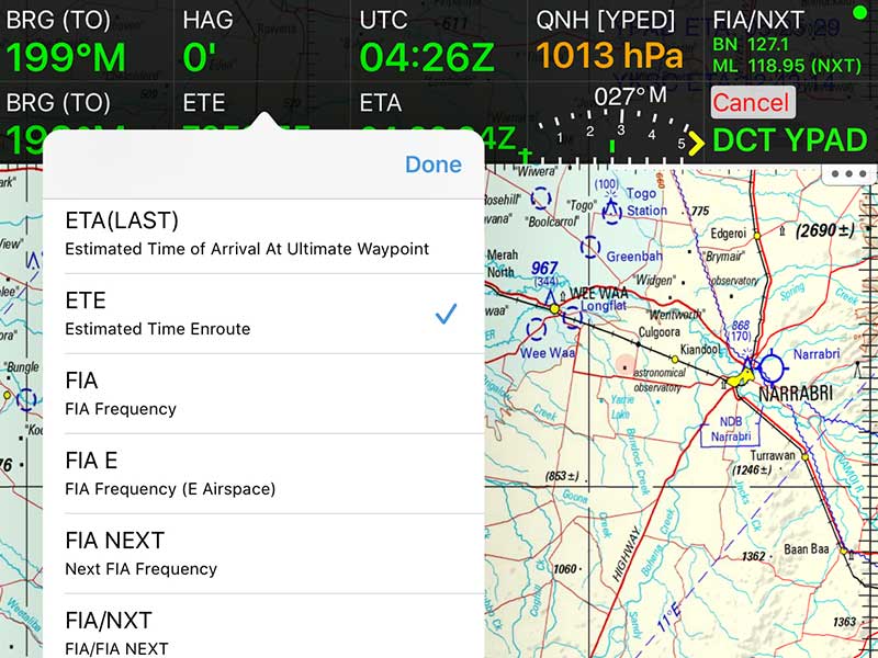
Frequency Navigator
Whether you need to locate ATIS, TWR, or VOR frequencies, we've got you covered with a curated shortlist on the Closest Points popup. Forget the cumbersome process of sifting through ERSA (in AU) or AIP (in NZ) pages or banking solely on your memory.
Traffic Bubble Improvements
You can now tap and hold the traffic button (map page, top right) to temporarily enlarge all traffic currently on the map. Use the traffic bubble size slider in the Traffic menu to increase or decrease bubbles as required. If long-range traffic bubble plans look a little different, we’ve updated them to now reflect great circles.
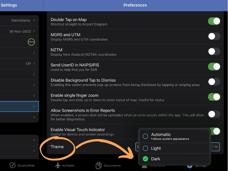
Dark Mode
Get ready to try our new app-wide Dark Mode! Turn this functionality on, off or set it to follow your device settings, via: Settings → Preferences
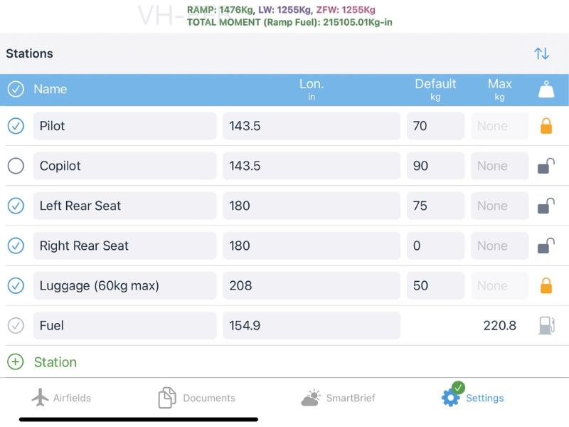
Weight and Balance Revamp
W&B now supports multiple envelopes in a single configuration, e.g. 'normal' and 'utility' category. Add key limitations such as Zero Fuel Weight, Max Landing Weight, and Max Ramp Weight.
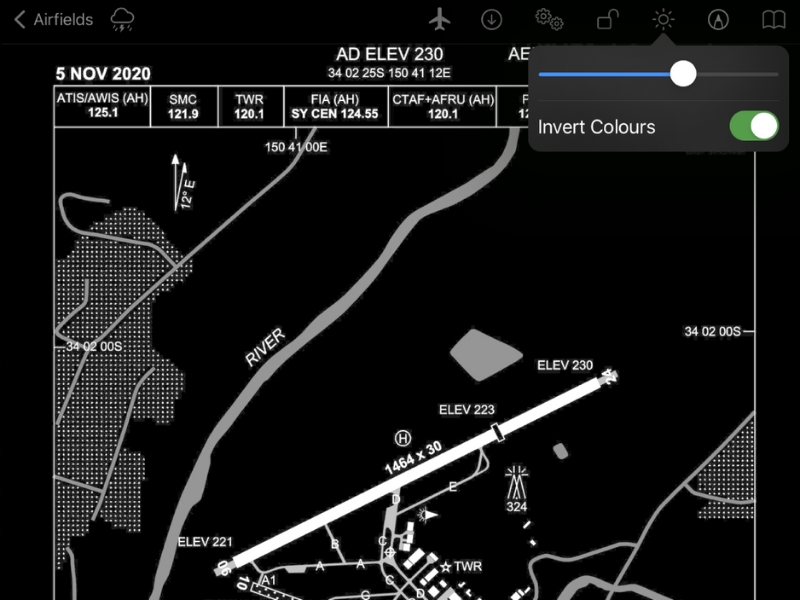
Invert Plate Colours
A new on/off toggle option has been added to invert colours on all plates. To use this feature, ensure Dark Mode is enabled via Settings > Preferences > Theme > Dark, then simply tap the brightness icon on a plate to try it out.
As well as dozens of other minor changes, improvements and bug fixes.
Highlights From v10
Smart Terrain with LSALT Assistant combines the most accurate terrain and obstacle data available with a completely transparent interface to make planning the lowest possible LSALT reliable and fast.
v11 requires iOS/iPadOS 13 or above
Smart Terrain
The dynamic Smart Terrain overlay shows terrain around you based on accurate NASA mapping data, making sure you know where not to turn. It's also smart enough to know when you are on the ground or on final approach so it won't red-out and make the screen unreadable.
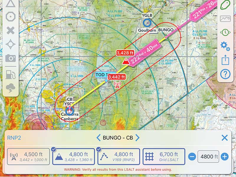
LSALT Assistant
The new LSALT Assistant is based on high resolution NASA terrain data and the latest Airservices obstacle database. By showing exactly how the altitudes are calculated you can be confident your LSALT isn't any lower than allowed, or higher than it needs to be.
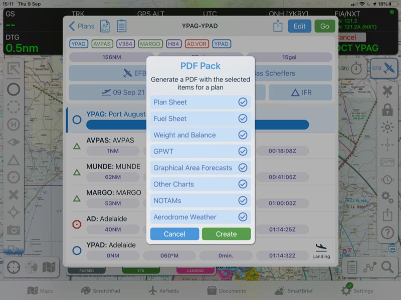
PDF Packs
Save or print a PDF with all the record keeping you need to complete commercial operations. Now more precise, concise and easier to read.
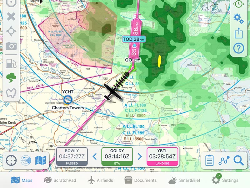
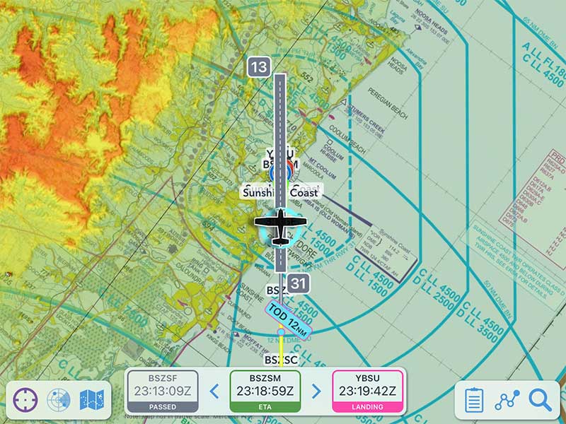
Great Progress
The re-styled plan progress box can be placed anywhere on screen for quick access to station passing time, next and final ETA.
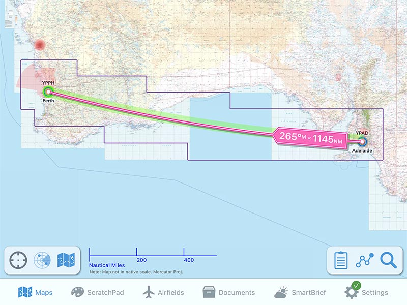
Greater Circles
Great circle mode is now the default throughout the app. Cross country, over the poles or through the dateline; bearings and distances look great.
As well as dozens of other minor changes, improvements and bug fixes.
So many plans, in so little time
OzRunways makes flight planning quicker and easier than ever before
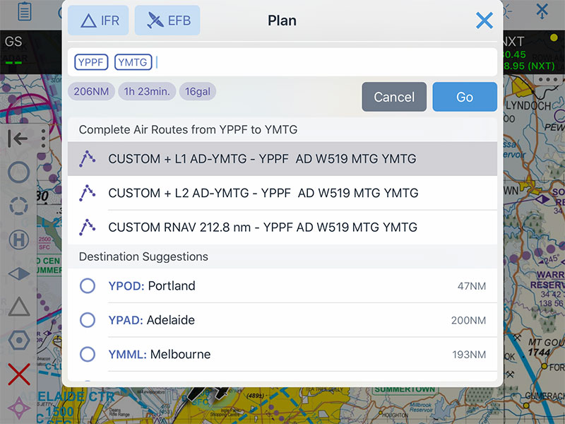
Plan Quick
Quick plan lets you type in, and autocompletes, any airport or waypoint name or code, and for IFR flights even suggests airways to use.
Tap and Go
Create your plan by tapping waypoints on the map. Pick up a track and drag it to insert a waypoint, or create a new custom waypoint anywhere.
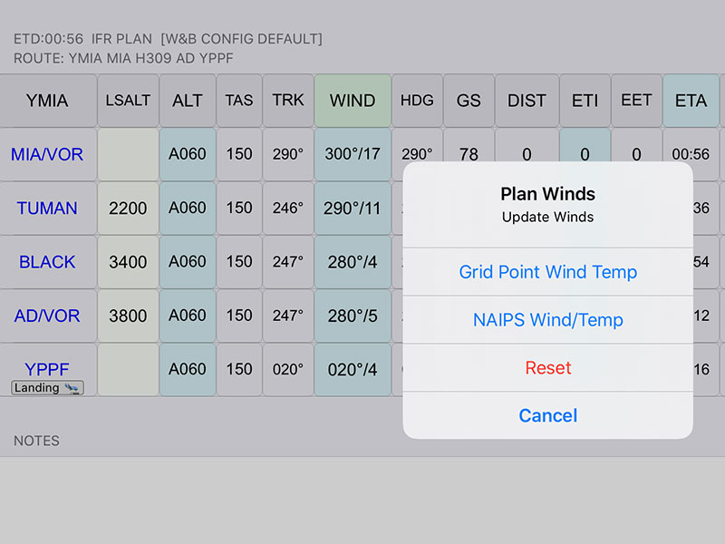
Winds
Automatically load wind from GPWT (low level) or NAIPS Wind/Temp profile (FL140+) for accurate time and fuel use.
Weight and Balance
Take the guess work and drawing lines out of your weight and balance. Just enter weights for each station for an accurate calculation.
Brief Smart
SmartBrief is the fastest way to get a complete picture of all weather and NOTAMs on your route and your departure and destination.
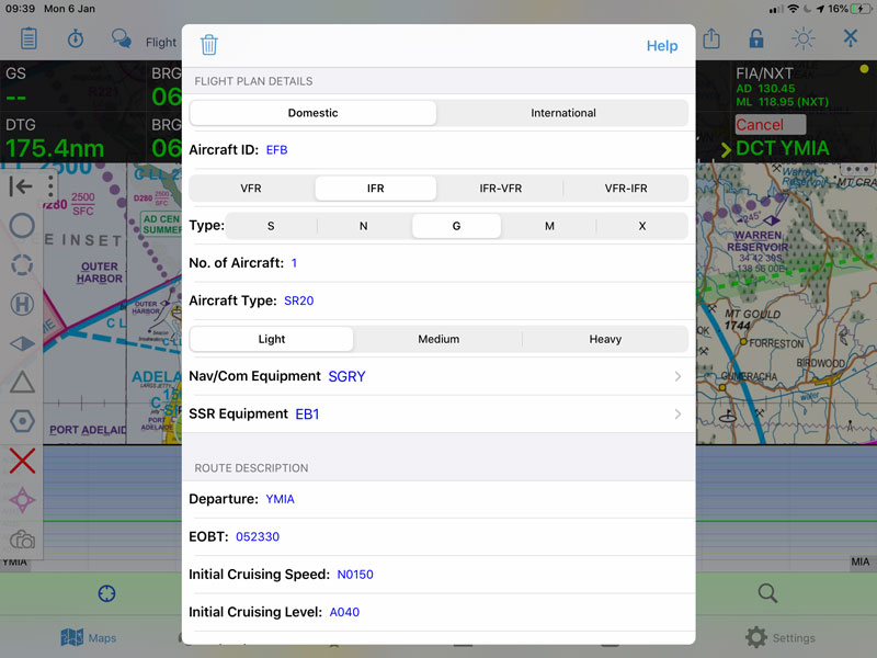
NAIPS Integration
File your plan directly from OzRunways, using the familiar form, pre-filled. Double check and make minor changes and send it to NAIPS.
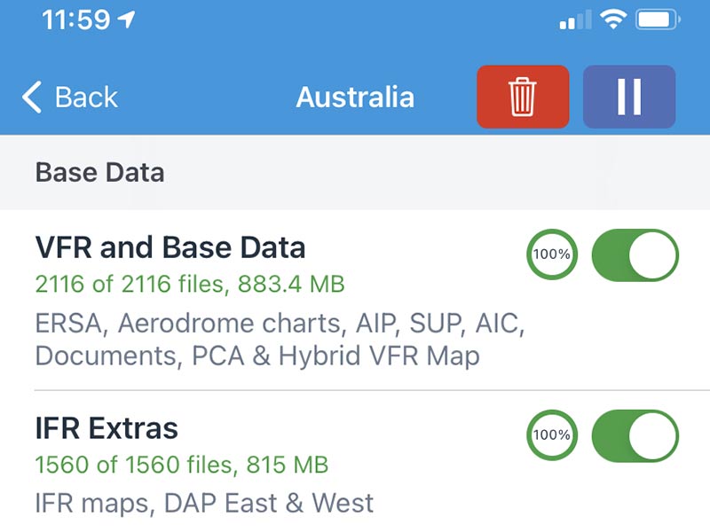
Auto Downloads
OzRunways keeps your data current - even in the background while you sleep. It also cleans up after itself by deleting outdated files and documents.
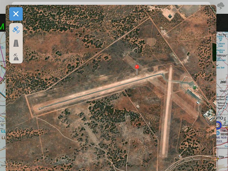
Bird's Eye View
The new satellite view of any waypoint is bigger than before, can switch to road maps and be used to fine-tune user waypoint locations.
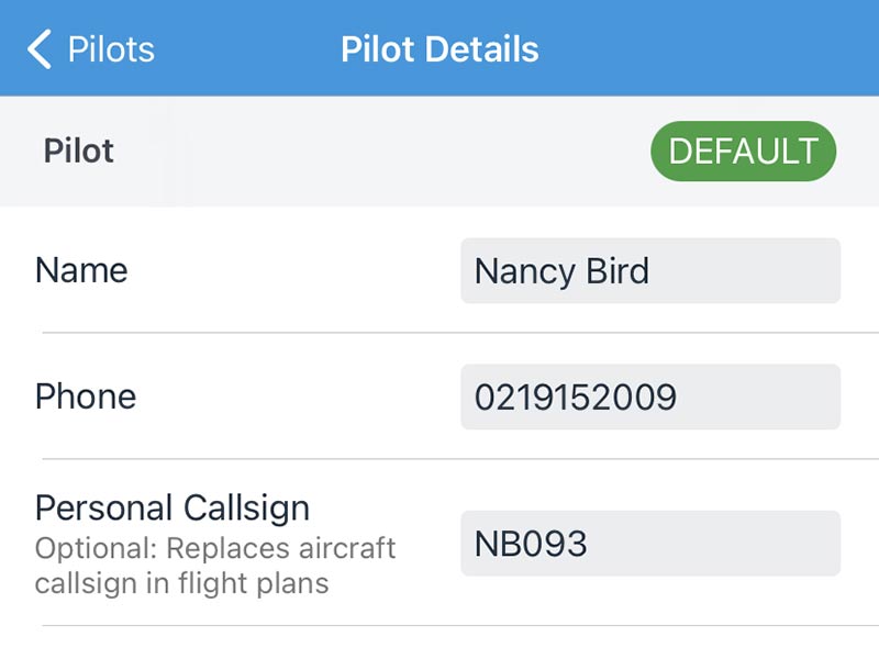
Get Personal
Does your company use personal callsigns? Add them to your pilot profile and it will be used in flight plan submissions.
SmartBrief
A graphical revolution in pre-flight briefing.
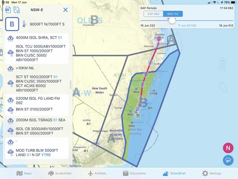
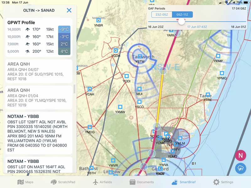
Interactive Graphical Area Forecast
SmartBrief takes the Graphical Area Forecast (GAF) data and presents it in a fully interactive format. Pan and zoom the map, tap on areas to read the forecast and decode the text into plain English. Now you can not only plan in minutes, you can brief your entire flight in minutes too.
Details for every route segment
A touch of each track segment brings up a complete overview of wind, temperature and NOTAMs that affect your flight. With SmartBrief you can brief more accurately in minutes, no printing required.
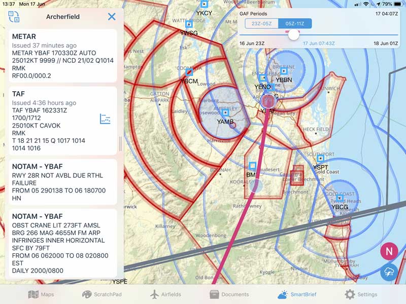
Airports Detailed
TAF, METAR and NOTAM for airports is available at a touch in SmartBrief and we even find FIR NOTAMS that affect the location so you're unlike to miss important ones hidden by unlit cranes.
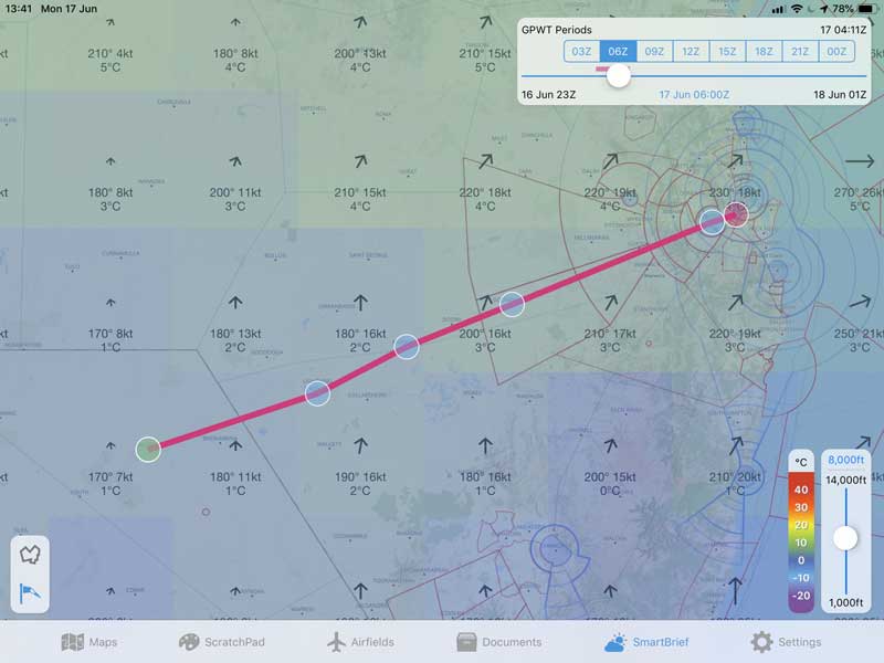
GPWT Decoded
A picture says more than a thousand numbers scattered on a map. An interactive picture is revolutionary. SmartBrief shows the GPWT forecast with sliders for time and altitude so it's easy to get a comprehensive picture of the wind along your planned route.
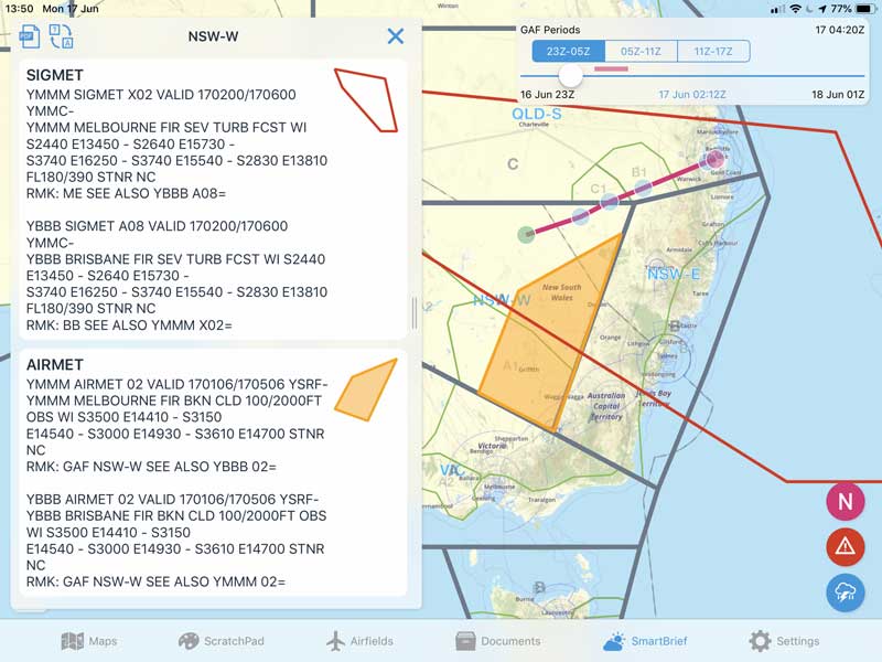
Visual SIGMET
SIGMET and AIRMET are overlayed on the GAF display in SmartBrief, making it easy to determine which ones affect your route.
IFR ∞ Evolved
Find the best routes in seconds with the smart IFR tools in OzRunways
Cleared for the approach
Easily add all the points in an RNAV approach to your flight plan; just rubberband an IAF and OzRunways will offer to load the entire approach.
Quicker Plan
Quick Plan in OzRunways 8 is smarter than ever, auto completing not just identifiers but also location names, suggesting air routes and even destinations.
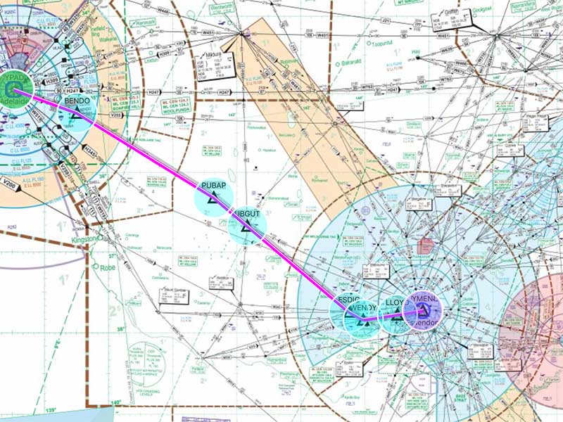
National ERC
We've stitched all the ERCs together into a low and high national map. Plan a long cross country without switching maps and when more detail is required, switch to individual TACs.
Lower, safer
LSALT Assistant is based on high resolution NASA terrain data and the latest Airservices obstacle database. By showing exactly how the altitudes are calculated you can be confident your LSALT isn't any lower than allowed, or higher than it needs to be.
File at a touch
With all your perfomance and times automatically calculated and aircraft equipment details stored, it take just one tap to fill out the flight planning form, and one more to submit it to NAIPS.
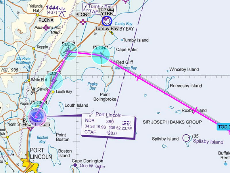
Geo-referenced Procedures
See where you are on the approach with our geo-referenced DAPs. Your own location as well as any nearby ADS-B or OzRunways traffic is displayed on aerodrome diagrams, and approach, SID and STAR plates.
Complete Situational Awareness
Know where you are, know where you're going
Hybrid VFR Map
The OzRunways Hybrid VFR Map provides a single Australia-wide VFR map, zooming from the WAC to VNC, VTC and even insets so you never have to worry about selecting the appropriate map.
Smart Airfield List
Smart Airfields is the quickest way to get to the documents and plates that you need. A single screen lists all the airports in your plan, your nearest airports and recently accessed documents.
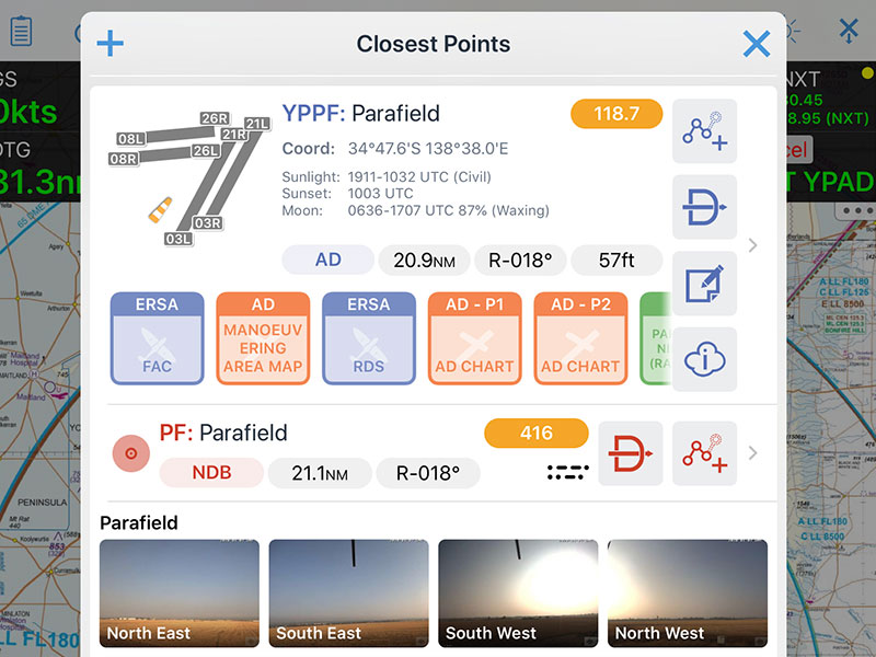
Quick and Concise
Tap on any airport and the most important information will be right there for the taking. And with a single tap more can be briefed or added to plan.
Instant weather
Get the latest weather and NOTAMs at the touch of a button.
Restricted Area Status
The status of restricted areas is displayed live on any map, making "please explain" letters a thing of the past.
Make it your own
The HUD can be configured just the way you like it, including advanced features like current and next centre frequency, QNH for the nearest airport and height above ground.
Own the Night
Support for smart-invert colours throughout the app keeps your night vision intact.
Paperless Notes
Go paperless using scratchpad. Easily copy clearances, ATIS, or any other reminders. And if you make a mistake, you can undo it with just a tap.
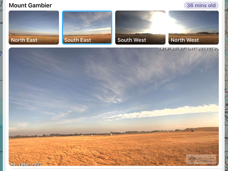
Weather to Fly
A picture says more than a thousand PROB30s. See the weather at many airports with your own eyes through Airservices' and our partners' webcam networks.
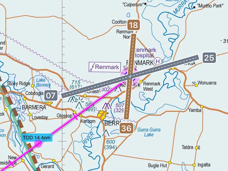
Runway Directions
Turn on the runway directions for easy orientation on arrival.
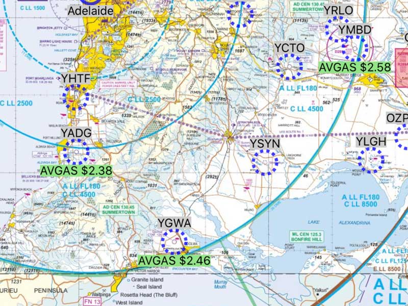
Fuel Prices
Pilot-provided fuel prices displayed on the map not only quickly show where fuel is available, but also how much you can expect to pay.
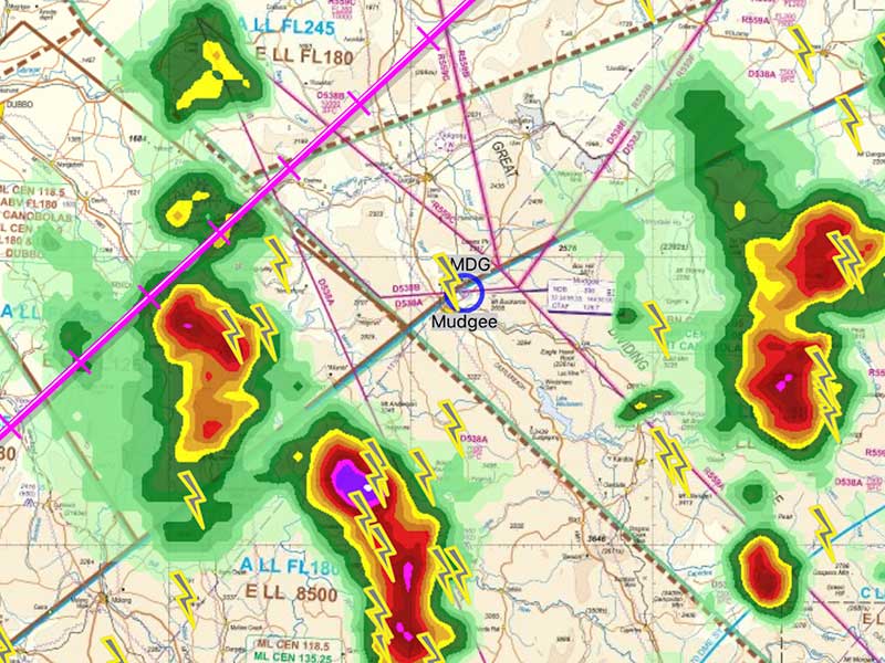
Thunderbolts and Lighting
...and rain aren't nearly as frightening if you know how to avoid them. High resolution BoM radar and satellite data show where not to go.
Document Library
The complete AIP, plus your own documents
Official Sources
Quick access to all the ERSA chapters, AIP and even CAO, CAR, CASR, MOS, CAAP and AIP SUP.
Add your Own
Just tap "Open in OzRunways" on any PDF on the web, email or files app to store your flight manuals in your EFB.
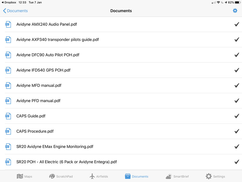
Dropbox Integration
Sign in to Dropbox and access all your documents without leaving the app.
Go your own way
Plan the perfect $100 $500 hamburger, weekend getaway or outback adventure
OzRunways Airfield Guide
Maintained by our in-house data team, the OzRunways Airfield Guide is the most complete and up to date source of information about thousands of small council airstrips, outback stations and private runways, many of which are not in ERSA.
Get details about runways, facilities, contact details, local information and more.
And no need to wait for new editions either as the guide is updated as soon as new information becomes available.
Pilots Touring Guide
Curated by Ian Baraclough from many years, the Pilots Touring Guide is a must-have source of information on the best places to visit, where to stay and where to eat.
As well as hundreds of pages for many destinations, a dedicated maps allows you to plan anything from a daytrip or weekend getaway to weeks long outback flying adventures.
See, be seen and get found
OzRunways and ADS-B traffic
OzRunways TX
Using our own super efficient protocols, we use the mobile network to track your location and show other OzRunways pilots on your iPad.
Low-cost ADS-B IN
Add an ADS-B receiver to your flight bag and see even more traffic, including the airliners sharing the circuit at uncontrolled aerodromes.
SIM cards save lives
Pop a SIM card in your iPad, it may save your life. Using OzRunways TX, your friends and family can see where you are in most locations and because all the data is archived, so can rescuers if you go missing.
When required, SAR officers at AMSA's rescue coordination centre have direct access to last known locations of any flights and if they need someone to help them sift through more data, OzRunways staff are available to help 24/7.
Not only has this saved many hours of searching and located those who simply forgot to cancel SARTIME, it has saved the lives of people stranded in remote locations with no other clues as to their wherabouts.
So get a 1-year pre-paid SIM from Telstra for the best coverage; it could end up saving your life.
Log your Flights
The most advanced tracking makes reviewing your flight and keeping logbook up to date easy
On the web
OzRunways TX records your location every 5 seconds when in mobile coverage. Log in to your account on the website to see all your flights on any device.
On your iPad
Our detailed second-interval logs are so smart, they'll even tell you which runway you landed on. And you can export the data in various formats to view and analyse.
Send to your logbook
Logging your hours in LogTen Pro is done at the touch of a screen. And it doesn't matter if your log is on the iPad you flew with, your phone, or your Mac, you can send it anywhere.
Get Started
Download OzRunways from the App Store for a 30 day free trial